")


The Appalachian Trail will change your life, but maybe no single mile of it will. Unlike its great western counterparts along the Pacific Crest or the Continental Divide, the United States’ most iconic footpath is subtle—a green tunnel through some of the oldest and most graceful mountains in the world, not some sizzle reel of endless panoramas. You can stand atop a 14er or a high Sierra pass and instantly feel altered; the AT takes time to shape you over miles, months, years.
While it’s hard to pick a birthday for the trail, which Benton MacKaye proposed in 1921 but wasn’t completed until 1937, you could reasonably say the founding of the Appalachian Trail Conservancy (ATC) in 1925 was when the AT became what it is. While the ATC has had its fair share of controversy, no other individual or organization has ever done more to protect and promote the trail’s 2,197.4 miles and the land around it. At a time when federal resources for public lands are in the air at best, the ATC continues its century-long mission to safeguard the trail, from volunteers they lead on crucial maintenance missions to their audacious Wild East project.
In that spirit, two of us who have had our lives changed by the Appalachian Trail—Backpacker writers Mary Beth Skyllis and Grayson Haver Currin—have selected our “best” 100 miles of the Appalachian Trail. (Fine, it’s 103.8, but more trail is better than less.) All these mileage markers represent a northbound hike and are subject to change, like the trail itself.
We debated these picks, arguing about their accessibility, their beauty, the way they loom large in our memory. Underneath it all, we were discussing the ways certain bits of land strung together by white blazes had changed us. Not everyone has the opportunity to thru-hike, but there’s a chance, that these 19 chunks of trail, from a 14-mile roller coaster in Virginia to the climb up Katahdin in Maine, can still change you, anyway.
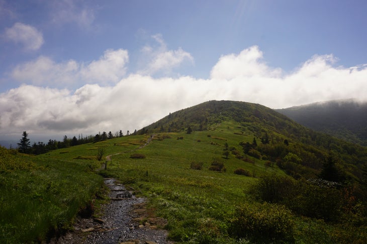
Prologue: The Arch to The Stairs, Georgia
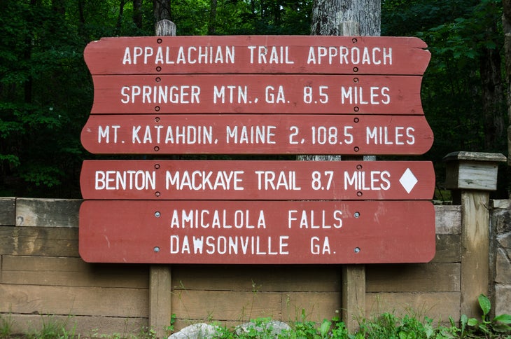
Though the Appalachian Trail officially begins on Springer Mountain before heading (at least at the moment) 2,197.4 miles to Maine, you should begin at Amicalola Falls State Park, beneath a simple stone arch. This is the 8.5-mile Appalachian Trail Approach, infamous for being debated by thru-hikers for its value and the 600-plus stairs to the top of the falls, which are as entertaining and challenging as almost anything on the actual Appalachian Trail. Legend has it that would-be thru-hikers have jettisoned their entire kits while climbing those stairs, returning to the parents still waiting below. And you will stun a dozen tourists when they ask you where you’re going and you simply answer “Maine!” The falls, it should be said, are beautiful; pose for a photo, and keep grunting up that hill. —GHC
Blood Mountain to Neel Gap, Georgia (3.2 Miles: 28.1-31.3)
Blood Mountain is one of the first landmarks for northbound AT hikers. It’s also the highest peak on the Georgia section, the sixth highest in the state. But it’s best known for another reason: ghosts. Some hikers point to the peak’s history as a battleground between the Cherokee and the Muscogee people as the origin of the stories. Others point to Meredith Emerson, who went missing in 2008 on the mountain, to explain its shelter’s eeriness. The trail log is often full of stories about strange occurrences from those who are brave enough to stay the night. —MBS
Rocky Top and Thunderhead Mountain to Beechnut Gap, North Carolina/Tennessee (2.8 Miles: 184–186.8)
The 72-mile path that the AT takes through Great Smoky Mountains National Park could have commandeered nearly three-quarters of this list, but that would be a copout. Still, less than 200 miles into a northbound journey, the Smokies offer a quick study on how the trail will push you around (if you take four days to hike the Smokies, the adage goes, you will encounter four seasons) and how stunning the whole thing will be. I love the wide-open views from Rocky Top and Thunderhead, plus how quickly you exit and reenter tree line. (There are some century-old names carved into rocks along the trail, too, predating the park itself.) And I have a distinct memory of being battered by wind so much that these mountains, as low-slung and ancient as they are, reasserted their power. —GHC
Max Patch Road to Lemon Gap, North Carolina (6.2 Miles: 254.6–260.8)
Before and after my first AT thru-hike, I lived in a cabin a few ridges over from Max Patch, one of those high balds scattered through the South. They can be so idyllic you will feel like you’re in a beautiful dream. It was essentially my backyard, so I’ve hiked to, on, and around the iconic spot maybe more than anywhere else. Still, I’d accept an invitation right now. A panopticon of Appalachian grace, it offers views of multiple states, distant ridgelines, and several river drainages. And the northbound descent down its gentle slopes and across multiple creeks into Lemon Gap exemplifies the woods of the region—wildflowers sprouting through the damp forest floor in spring, a look at the bones of some of the world’s oldest mountains with fall’s arrival. —GHC
Views of the Nolichucky River to Beauty Spot, Tennessee/North Carolina (11.7 Miles: 343.5–355.2)
Talk to a veteran AT hiker, and chances are you’ll get a strong opinion about the green tunnel, or the prevailing sense that you’re mostly navigating 2,200 miles of tree cover from Georgia to Maine. They’ll say it’s boring or it’s beautiful. I say it’s both, and the moments when it breaks affirm that. As you head into Erwin, Tenn., the trees split onto postcard-worthy shots of the Nolichucky River’s gorge far below. And after you cross the river (post-Tropical Storm Helene, you’ll do it by ferry), you’ll steadily ascend a series of gaps and ridges, views offered by powerline clearings and natural overlooks alike. Just shy of 4,500 feet, you’ll reach Beauty Spot, a mountaintop meadow ringed by little trees, so picturesque you may be tempted to make it your permanent address. I first encountered Beauty Spot after getting off trail for a funeral; it was the sight that galvanized my northward quest. —GHC
Cloudland Hotel on Roan Mountain to Little Hump Mountain, Tennessee/North Carolina (9.3 Miles: 378.7–388.0)
I have always struggled with the obvious question: What is your favorite part of the Appalachian Trail? No one ever accepts “all of it,” so I soon launch into a list that feels just shy of “all of it.” But if my life depended on recommending one stretch, this right here is the one: From the top of rhododendron-crowned Roan Mountain, where remnants of the grand Cloudland Hotel remain, you drop into a seesaw of dips and dives, the rugged old trail carved across the faces of some of the oldest mountains in the world. You cross three balds in a little more than a mile, drop way down, and then climb Little Hump Mountain. (The section misses some charm now since the loss of the fabled Overmountain Shelter, but it still goes.) I stupidly camped on its flanks once during a strong storm, and weathering that felt like preparation for future, bigger adventures. The next morning, the sky was all cotton candy, and I briefly wondered if I might have slipped off in my sleep toward heaven. —GHC
Dennis Cove Road to Laurel Fork Falls, Tennessee (1.2 Miles: 420.3-421.5)
Located in the Pond Mountain Wilderness just outside of Hampton, Tenn., a strenuous stretch of trail takes you to the 40-foot tall, 50-foot wide Laurel Fork Falls. While springtime air temperatures are often in the high 70s or low 80s, the falls are notoriously cold. That doesn’t stop hikers from going for a soak, even in early spring. My trail family and I packed out a few beverages from the Black Bear Resort and stuck them in the water during our ice baths. By the time we were done splashing, they were ready to sip. —MBS
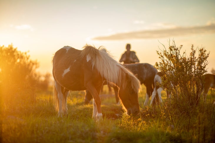
Buzzard Rock to Mount Rogers, Virginia (7.3 Miles: 491.9-499.2)
By the time I made it to Buzzard Rock, I finally had my trail legs. The climb to the summit of Buzzard Rock is a little bit of a monster, but for the first time in nearly 500 miles, the strain barely phased me. What’s more, the whole section offered 360-degree views, made even more beautiful by springtime blossoms. The bald-style peaks in this region make for consistent views across the Grayson Highlands, a stretch of trail known for wild ponies grazing around Wilburn Ridge. —MBS
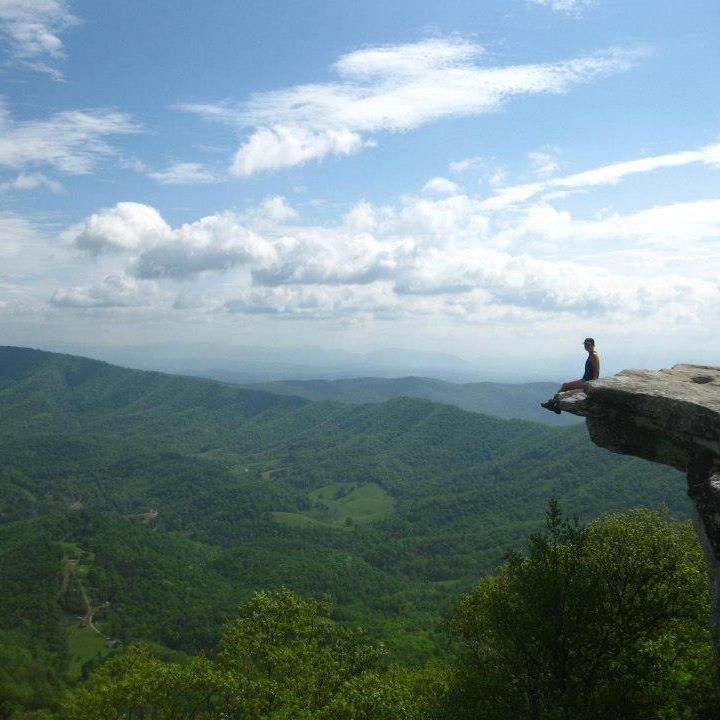
McAfee Knob to Tinker Cliffs, Virginia (5.6 Miles: 714.5–720.1)
McAfee Knob is the most photographed overlook along the Appalachian Trail—and for good reason, since the view it offers feels so epic. But truthfully, I found nearby Tinker Cliffs to be equally stunning, minus the crowds. After McAfee Knob, the trail winds through trees and shrubs before climbing through some boulders to a cliffside that gives you access to several different overlook options. You can complete the Virginia “Triple Crown” by adding the Dragon’s Tooth. —MBS
The Roller Coaster, Virginia (14.0 Miles: 996.4-1,010.4)
Reaching the 1,000-mile mark of a northbound thru-hike, which you do during this infamous stretch, is a bit of an emotional rollercoaster in itself, but these 14 miles are better known for their literal ups and downs. The elevation profile is so tedious and repetitive it’s almost comedic. I carried an avocado for a friend through this section, contemplating whether or not I should just eat it myself to save my knees from 7 ounces of extra weight. My spirit proved valiant despite more than 3,500 feet of gain. After failing to find my friend after three days, I sliced the avocado into fat chunks, placed it on a burger I bought, and ate it myself, anyway. —MBS
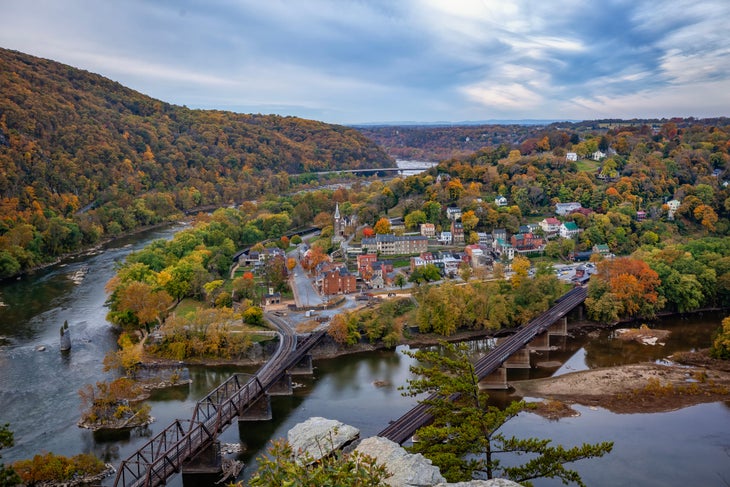
Harpers Ferry, West Virginia (4.4 Miles: 1,025.4–1,029.8)
The AT’s 2,200 miles are chockablock with history, from the indigenous thoroughfares it overlaps to the battlefields it bypasses. But few places in the United States are crucibles of the country’s struggles and progress quite like Harpers Ferry. A gap in the ridge and the confluence of the Potomac and Shenandoah rivers so close to D.C. essentially ensured important events, like the de facto start of the Civil War, would occur here. An idyllic town suspended in amber, Harpers Ferry is glorious on a spring day. Cross the Shenandoah by footbridge and then the Potomac (and into Maryland). Cruise the first few miles of the state on the C&O Canal Trail, surrounded by lush woods and families pushing strollers. The home of the Appalachian Trail Conservancy (happy anniversary, and thanks!), Harpers Ferry offers a perfect break at what we call the AT’s “emotional halfway point.” —GHC
New Jersey-New York State Line (1.9 Miles: 1,369.7–1,371.6)
A recovering van dweller, I was a state-line enthusiast long before I began thru-hiking, curious about how sometimes-arbitrary distinctions between this and that could impact people’s lives. Maybe the AT made a zealot out of me, crisscrossing as it does 14 states. My favorite crossing happens when, after dancing across the border multiple times, the northbound trail exits New Jersey (great AT state, by the way, for real) into New York. The distinction is painted blaze-white on a massive hunk of rock, part of a series of very brief scrambles (with occasional ladders for help) and open rock faces that offer expansive views of tree-lined ridges, deep blue lakes, and small towns. Few other bits of the AT are quite like it. Bonus: You’re very close to Bellvale Farms Creamery, some of the trail’s best ice cream. —GHC
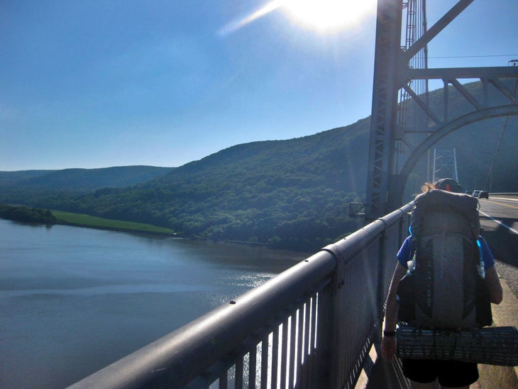
Bear Mountain Recreation Area to Anthony’s Nose, New York (2.3 Miles: 1,408.2-1,410.5)
The stretch of Appalachian Trail that runs past New York City marks an odd juxtaposition between the trail’s quiet backcountry and civilization. I made it to Bear Mountain just before Father’s Day on a balmy summer afternoon, noticing locals gathering for picnics near the lake. Upon reaching Bear’s summit, I spotted a rattlesnake, poised and ready to strike, just seconds before I peered across the New York skyline. Continuing north, I made my way past a small zoo before crossing the Hudson River on the Bear Mountain Bridge. By the time I reached Anthony’s Nose on the other side, my brain was still processing a rattlesnake, a skyline, a zoo, and a sprawling bridge in a matter of miles. —MBS
Route 9/Split Rock to Glastenbury Mountain, Vermont (10.4 Miles: 1,618.0–1,628.4)
Vermont doesn’t get the Appalachian Trail love it deserves. If you’re headed north, you’re anticipating the big bosses at the end; if you’re headed south, you’re anticipating the four-state rush that begins with Massachusetts. But the 151-mile stretch through Vermont is memorable because of its seasonal mud, its rendezvous with the Long Trail, and its absolute wealth of rich forests, broad meadows, and dreamy ponds. Easily accessible from Bennington, this 10-mile span is an unexpected gem in the Glastenbury Wilderness. You’ll pass through a striking split rock, ford a stream, navigate slippery boardwalks through forest so green it feels like a sea of melted crayon, and slowly climb nearly 2,000 feet to a lookout tower where the woods blur into a horizon of endless ridges and sky. Get there at sunset, and you’ll instantly understand that Vermont is possibly the AT’s most gently exquisite state. —GHC
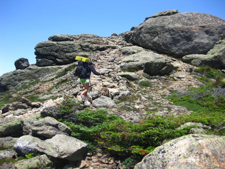
Franconia Ridge to Mount Garfield, New Hampshire (7.0 Miles: 1,827.0–1,834.0)
Franconia Ridge greeted me with 50-mile-per-hour winds, making it difficult to stand at my full height. Still, the views were worth it. The majority of this trail section is above treeline, making it high on exposure but easy on the eyes. As the day wore on, the wind died down just in time for me to make the steep climb up majestic Mount Garfield, studded with tiny trees like so many of its White Mountain kin. —MBS
Lost Pond to Carter Notch Hut, New Hampshire (5.2 Miles: 1,878.5–1,883.7)
The White Mountains are not for the faint of heart, as the Wildcat Mountains taught me. This section of trail required rock scrambling, squeezing myself through small spaces, and crawling at a snail’s pace due to the relentless elevation gain. In fact, if this section were any steeper, it could be placed on the Yosemite Scale and given a rock-climbing grade. Some even call this the AT’s most challenging bit. One quality that makes the Whites so unique is its hut system. The Appalachian Mountain Club operates eight huts across 50 miles, a potential relief for hikers who are looking to get inside for a snack or stay. The Wildcat stretch includes the Carter Notch Hut—quiet, beautiful, and a great place for a cup of coffee before continuing on. —MBS
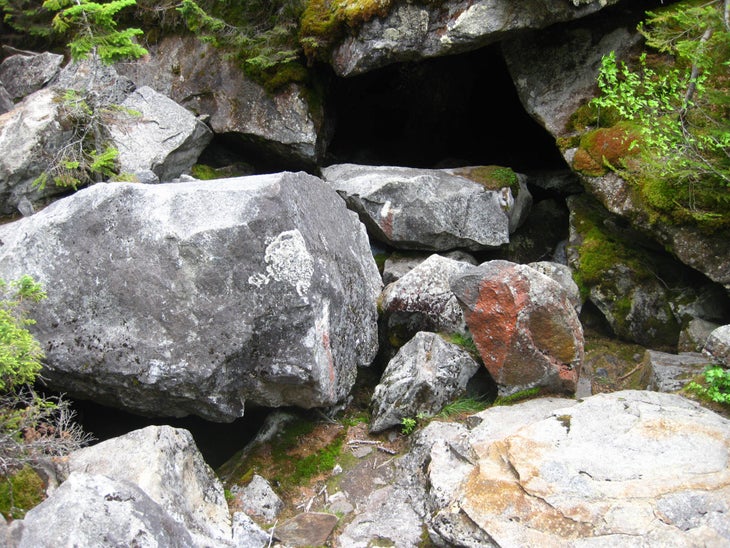
Mahoosuc Notch to Speck Pond Shelter, Maine (3.4 Miles: 1,922.0–1,925.4)
For 2,000 miles of the AT, you will resent switchbacks and PUDS (that is, pointless ups-and-downs), all moves the trail makes to get you where you need to go without ruining the landscape. In Maine, where native son Stephen King must have convinced some poor trail builder that building switchbacks would haunt them, hikers face hard climbs. This wondrous little stretch starts with the Mahoosuc Notch, a mile-long jungle gym of enormous boulders that you will climb atop, under, and around. Finish that, and it’s time for the Mahoosuc Arm, a 1,600-foot climb on a little more than a mile of rock that’s so consistently wet it seems to be leaking grease. Finish that, and it’s time for your true reward: the glorious Speck Pond Shelter, one of the most stunning places to spend the night on the entire trip. —GHC
Pemadumcook Lake, Maine (2.7 Miles: 2,149.1–2,151.8)
I will forever be grateful for the shores of Pemadumcook Lake, because that’s where, a few days into a trek of the 100 Mile Wilderness, I inexplicably found a bag of unopened Pop-Tarts, my favorite trail food. I ate them all. But when I see photos of that moment, I am wowed again by how massive Mount Katahdin appears on the horizon, though it’s still 50 trail miles north. In its isolation, especially against a pale blue morning, it looks like the continent’s biggest peak. No wonder Thoreau was shook. If you’re heading north, summit fever will soon set in, so take time to enjoy the way Katahdin frames this placid Maine lake. And maybe eat a Pop-Tart? —GHC
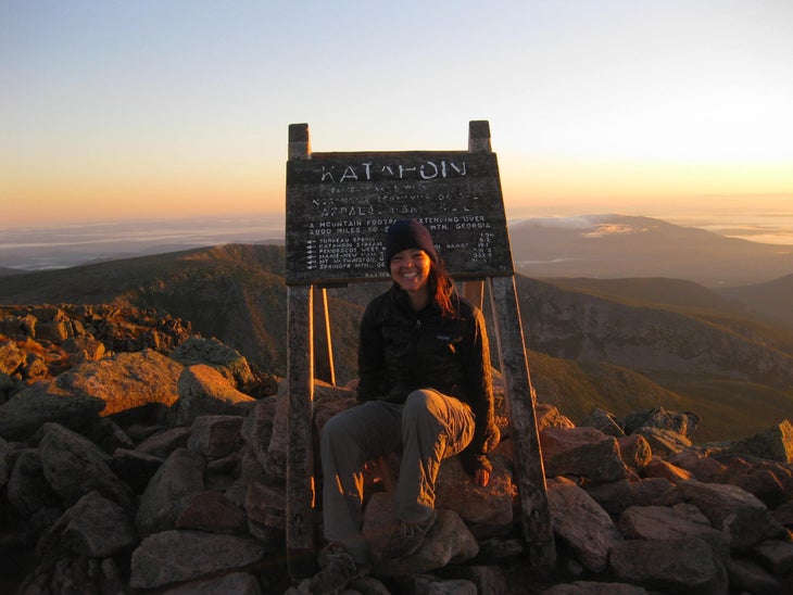
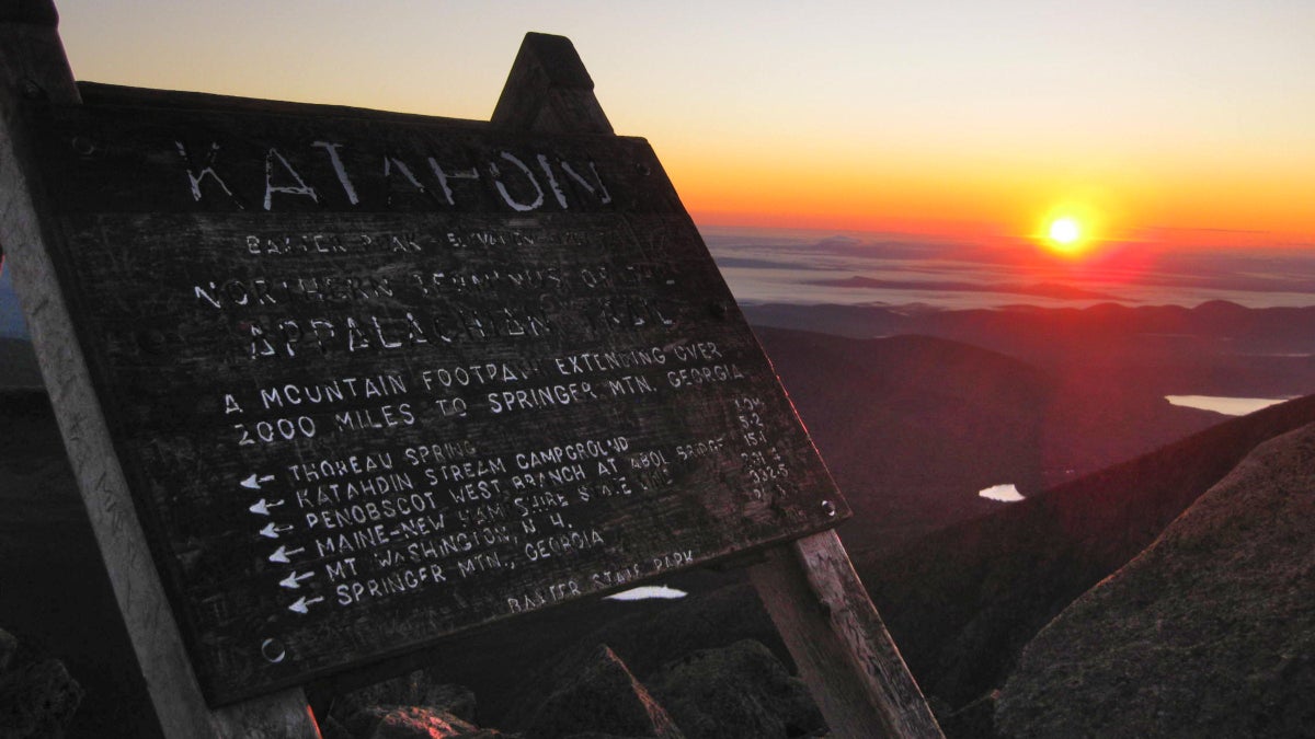
Katahdin Spring Campground to Katahdin Summit, Maine (5.2 Miles: 2,192.2–2,197.4)
Within days of finding my trail family in Georgia, our peers dubbed us “the Breakfast Club,” because we were infamous for waking up before the sun to catch sunrise on a summit somewhere. My hiking partner and I tackled Katahdin in the same spirit, rising from our quarters at Katahdin Spring Campground at 3 a.m. before beginning the ascent. Halfway up the climb, we turned to the sky and glimpsed the Milky Way, peppering the darkness with color. We slogged on, equal parts ecstatic and devastated to be nearly done. By the time we reached the summit of Katahdin, the sun winked over the horizon, making us some of the first people to greet a new day along the east coast while we ended our thru-hike. —MBS
The post What Are the 100 Best Miles of the Appalachian Trail? We Asked Two Thru-Hikers to Choose. appeared first on Outside Online.