On the first night of the Dientes de Navarino circuit in Chilean Tierra del Fuego, I burrowed into my sleeping bag in my tent perched on the banks of the alpine Laguna del Salto. When I peered outside, I saw an opaque gray sky and a jagged, silent landscape dusted with snow from the blustery weather. As I yanked my hat down to cover my ears, I noticed a feeling I’d never had on a backpacking trip before: I was burned out.
I’ve planned and executed dozens of backpacking trips, including a solo hike of the Colorado Trail. Usually, at the end of a tough day of hiking, I’m tired but still motivated to complete the adventure.
But that night on the Dientes de Navarino circuit, I felt different. We’d only hiked seven miles with about 2,500 feet of vert that day, but a late afternoon start, relentless wind, and zero visibility had limited our progress. While pushing through crappy weather wasn’t anything new for me, that night I felt a deeper level of exhaustion seep into the more profound layers of my being. It was emotional fatigue, a lack of that fiery determination that would usually get me through the discomfort and dread of icy days ahead in these mountains at the end of the world.
I shouldn’t have been surprised. I’d been running my life as a tight ship, traveling vigorously and working remotely for the previous year. I’d spent six months exploring Mexico from Jalisco to the Guatemalan border, then a summer in the Southern Hemisphere, traveling through Chilean and Argentine Patagonia and completing several multi-day hiking trips.
Managing my mobile lifestyle felt increasingly overwhelming. Deep in the Chilean backcountry, I began to crave stability and consistency. But I stubbornly maintained a vice-like grip on the vision of doing and seeing as much as I could on my way down to Tierra del Fuego before I needed to return to the U.S. for a family wedding. I gave myself periods of respite here and there, like a couple of months in Santiago and a month in the Argentine Patagonian town of El Bolsón, but I was beginning to realize these well-intentioned stints weren’t sufficient to soothe my scattered and travel-wearied soul.
Yet, every time some part of me whispered to stop, I ignored it. I simply could not turn away from the unbelievable luck I felt I had, having the opportunity to spend four months in one of the best hiking regions in the world during peak season. Making it down to the bottom of the Americas felt like a tantalizing adventure I couldn’t let go of.
My travel approach is usually centered around seeking the unsought. I was looking for remote, almost unheard-of trails, which is how I came to discover the Dientes de Navarino circuit one night in my apartment in Santiago, reading through the last hidden corners of my guidebook. When Google returned a scant few results about the trail, I knew I was on to something.
In The Voyage of the Beagle, Charles Darwin’s journal of his navigation around the Americas in the 1830s, he describes with awe the “savage magnificence” of Tierra del Fuego. One glance at the spiked peaks jutting into the somber gray sky, and it’s easy to understand why. The Dientes de Navarino mountain range, or “Teeth of Navarino,” so called for its jagged namesake peaks, is located in the Fuegian Andes on Navarino Island, one of the last landmasses before Antarctica. This small island is ever-so-fragmented from the main island, Isla Grande de Tierra del Fuego, with Cape Horn directly to its south.
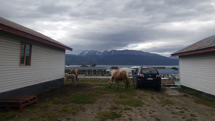
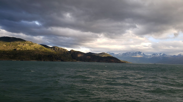
To arrive at Navarino Island, visitors must take a plane or 150-mile overnight ferry across the Magellan Strait from Punta Arenas, the entry point to Tierra del Fuego and the last city on the mainland before the terrain collapses into a network of glacier-covered fjords and islands. I arrived at the 3,000-person town of Puerto Williams, Navarino Island’s hub and the southernmost settlement in the world.
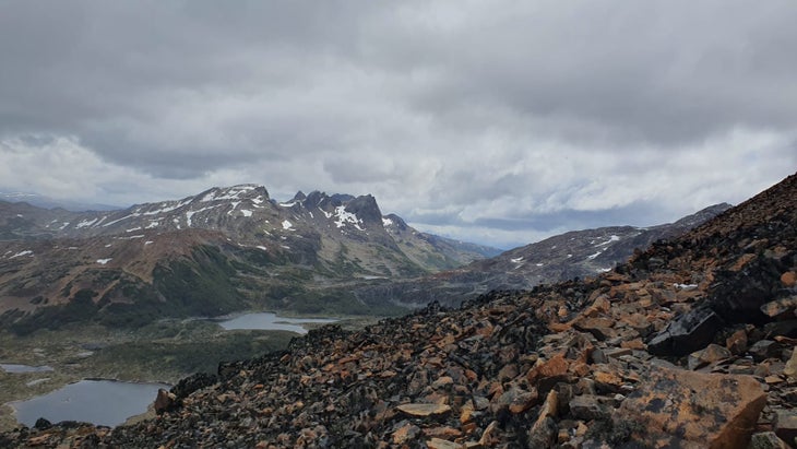
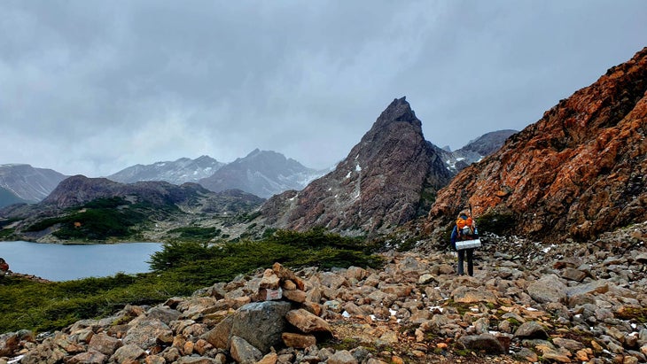
The island’s Dientes circuit is a remote and wild 27-mile route that circumnavigates the Dientes peaks with 7,000 feet of elevation gain, running through perpetually damp and cold subantarctic forest past lagoons, craggy boulder fields, snowy summits, and a variety of endemic trees, mosses, and lichen.
It’s challenging, principally due to badly maintained or nonexistent trails over rugged terrain and unpredictable, severe weather conditions. A single day in high summer can include anything from blue skies to snowstorms and violent subpolar winds. It’s difficult to plan your trip around good weather because of rapidly changing forecasts. Route finding is fundamental—and stressful. The way forward is often indiscernible, with trail markers like signs, cairns, and ribbons, few and far between.
Each of these factors wouldn’t be as daunting on their own, but put together, they can make for a formidable challenge demanding constant caution, forcing sometimes painstakingly slow progress when conditions are bad.
Of course, it was this guaranteed adventure that I could not resist. The fact that very few people I had met on my travels in South America had heard of the Dientes de Navarino mountain range told me I was headed to the right place. I spoke to anyone I could along my way who knew about it, and spent my evenings crammed into hostel bunks all over Patagonia, scrolling endlessly through hikers’ trip reviews on AllTrails. I decided to roll into town and see who else was planning to hike the trail.
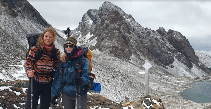
On a clear summer day in January, I arrived at my friendly hostel in Puerto Williams. Shortly thereafter, I received a WhatsApp message. “Hi! I got your number from AllTrails!”
(Weeks past, I had left a comment on the trail’s AllTrails webpage looking for hiking companions.) The woman who had messaged me was named Lisa. She was 26, from the Netherlands, and had recently embarked on a solo hitchhiking odyssey through South America. A savvy hiker who had completed many long-distance backpacking trips, I liked her spunk and fearlessness. After talking through logistics, we agreed to team up and tackle the trail together.
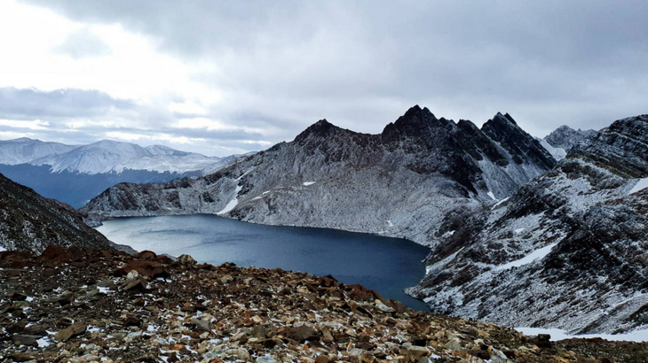
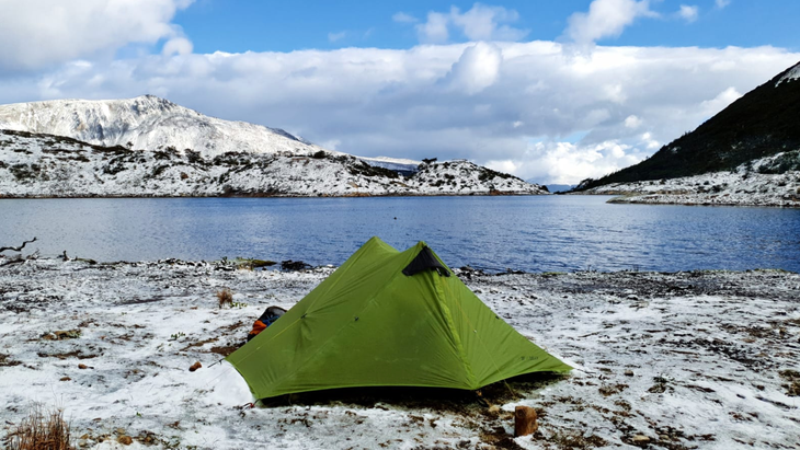
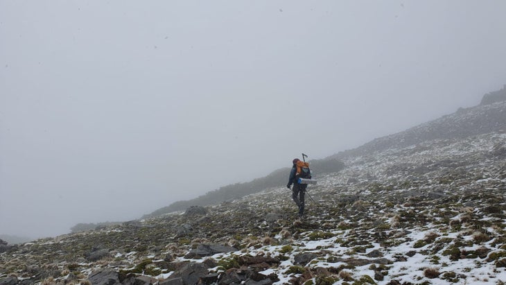
The day of our departure was gray and blustery, nothing like the glowing recent trip reports of gorgeous weather, which in this part of the world is a blessing seldom enjoyed. During the first few hours, we walked a pleasant path through the lush Fuegian forest, the darkness and cold giving the landscape a melancholy, gloomy quality. Eventually, the gusts and snow picked up, and once we broke above treeline heading up to the first of the circuit’s four passes, the rest of the day was a white vortex. We finally got to our campsite on the banks of spire-framed Laguna Salto.
There, in my sleeping bag that first night, I felt the oppressive weight of my type-A ambition bearing down on me physically and mentally. I felt devoid of motivation. I knew I was wildly fortunate to be sleeping in this otherworldly landscape, but, for the first time, I felt smothered by the months of constant motion. The captain of the Beagle, the ship Charles Darwin navigated around the Americas, said that the oppressively somber weather in Tierra del Fuego was such that “the soul of man dies in him.” His words, to my surprise, resonated.
I could’ve decided to turn around the next day and go back, but I didn’t want to abandon Lisa, and I also couldn’t bear to walk away from my goal. So I continued.
I endured three more days of an unrewarding suffer-fest. The morning of day two, navigating a slippery, icy rock face along the ridge up to Paso de los Dientes, staring down the sheer drop into the depths of the frigid Laguna del Paso below, I sunk further into mental fatigue.
My surroundings were as wild and gorgeous as I ever could’ve wanted, but I was weary and depleted. At one point, coming down the steep descent from that pass, I slid and fell in the mud. The weight of my pack lurched me forward, and I hit my knees on the sharp rocks sticking out of the forest floor. I burst into tears, more from the shock and emotion than the pain itself.
I knew in that moment that I was ready to listen to myself and take a break.
But I had to complete the hike first. Lisa and I put our heads together to hunt down precious trail marker after trail marker as we tramped through the miles of muddy peat bogs and twisted dwarf forest under the gently falling snow. Her zeal and upbeat attitude, even through the most unpleasant moments, kept me from descending further into a pit of negativity.
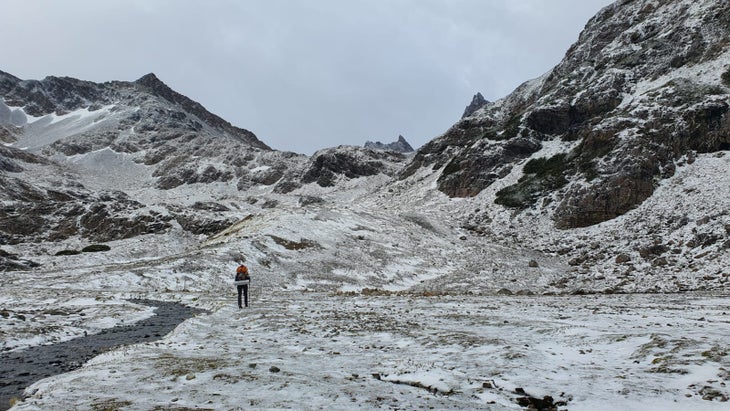
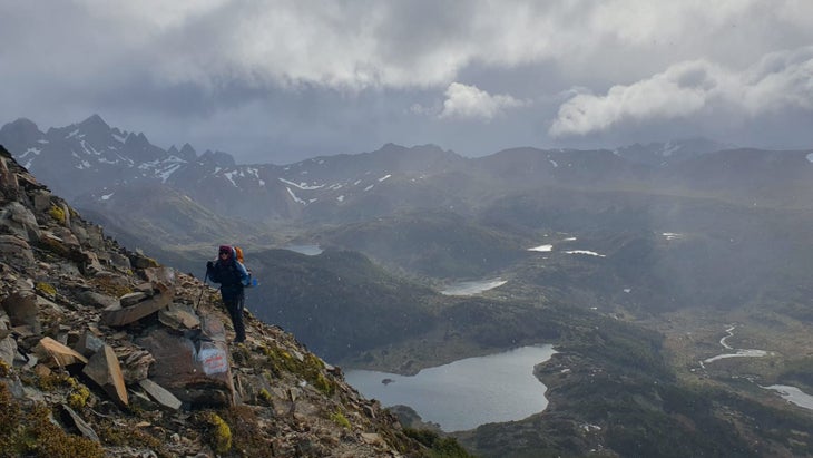
On the third day, we began our ascent up 2,800 foot Paso Virginia, the biggest pass of the circuit. We moved past the treeline and entered the alpine tundra. As we gained more elevation, the weather conditions deteriorated. We began to move farther away from the last flat, semi-protected patch of ground in view and headed through the boulder field toward the gray void above. It occurred to me that my extremities were as numb as I had ever felt them. My hands and feet burned and tingled so painfully that I could barely move them. I had been wet since the day before due to the constant precipitation and complete lack of sunshine, but it didn’t become an issue until we gained more elevation and hit worse weather and lower temperatures.
With so many unknowns ahead of us and with such poor visibility, I told Lisa we should pitch our tent to warm up for a while in that last flat spot before moving on. I wanted to stay for the night and let the snowstorm pass, but she reminded me that the weather would probably get even worse that night; coming down the other very steep side of that pass in fresh snow the following morning could be dangerous. We chose to forge ahead.
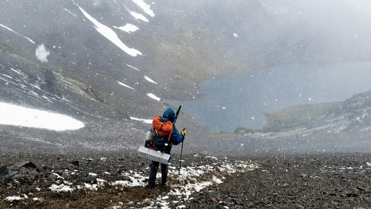
Arriving at the top of Paso Virginia, we peered down to find a heart-stoppingly steep scree slope down to the valley. A few ginger first steps into the loose jumble of small rocks, sand, and snow soon felt like skiing through gravel.
We made it down the pass and set up camp at the bottom just as the snowstorm started intensifying. My pack, which had always been totally waterproof in the climate back home in Colorado, had soaked through. This left my sleeping bag barely dry enough to keep me warm. I was cold and wet. Lisa offered me her extra dry clothes.
Miraculously, the next morning we woke up to civil, temperate weather that had caused the snow to mostly melt while we slept. I pulled on my icy trail runners with exhaustion, but also relief for the weather shift and excitement that we were so close to leaving this experience behind.
The biggest hurdle we had remaining was to work our way through the rest of the forest for the next few hours until we hit cow pastures, which would signify our proximity to civilization. Even though this last stretch was all downhill, it wasn’t easy.
The original trail had long since been dammed and flooded by beavers, which had arrived in the 1940s after an unhinged and ultimately disastrous plot cooked up by the Argentine government to start a fur trade. The lack of natural predators created a population explosion that has since led to forest destruction, waterway disruption, and, most pertinently for us, trail destruction.
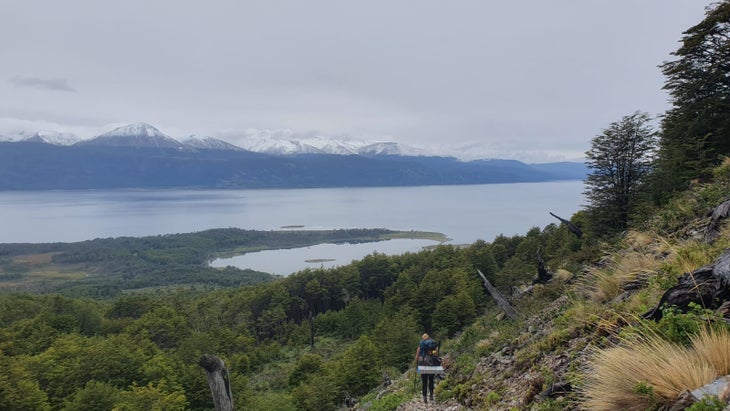
After a few hours of bushwhacking, we broke through the last of the beech forest and caught sight of the Beagle Channel stretching out in the distance. Looking out at the lumpy green cow pastures that indicated the last couple miles of trail, I felt a rush of relief.
As we emerged from the trail, we approached a quiet country road. We plopped down and waited for someone to drive by that might take us back to town.
Olivia James is Outside’s former newsletter producer. She writes about travel and health from Buenos Aires. Spending parts of her childhood in Asia ignited a love for adventure, which has led to her solo traveling and living in Latin America since 2018. You can follow her travels on her blog, and stay tuned for more of her stories for us at Outside, to come.

The post I Hiked the Southernmost Trail in Patagonia. Here’s What I Learned. appeared first on Outside Online.